| Editorial
Section - Area Information, The Levels and Moors, Somerset |
|
|
Contact
details
Levels
and Moors Project Officers. Telephone: 01458 210790
The Levels and Moors Office, Moorlinch Vineyards, Moorlinch, Bridgwater, Somerset TA7 9DD
www.somersetlevels.org.uk
|
SOMERSET
LEVELS & MOORS |
|
|
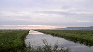
This beautiful and picturesque area lies in the very heart of Somerset. It has international status as one of the most important 'wetland' areas of its type in the world and covers 250 square miles. Essentially, The Levels and Moors 'wetland' is a huge, reclaimed marsh where pastures are divided by a network of ditches and drainage channels known as rhynes, rather than hedges and fences. |
| The
Landscape |
|
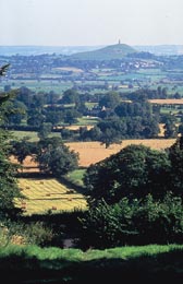
The
Levels and Moors form a unique flat, open landscape and the treeless
pastureland is dominated by distant views of the surrounding hills.
Most
of the area is no higher than 25ft above sea level, though the Levels
(coastal marine clays) are higher than the inland Moors which have
peat as its central feature.
These
areas are protected from coastal flooding by the clay ridge at the
coast and by the control of water by pumping.
To
the north of the Polden Hills this wetland is naturally supplied
by the rivers, Axe, Sheppey and Brue; while in the south, the main
rivers are the Cary, Yeo, Tone and Parrett. The latter is tidal
up to Oath Lock near Langport.
|
|
THE
SOMERSET LEVELS AND MOORS PARTNERSHIP
The
Levels and Moors Partnership was formed in 1995 in response to finding
a new way of working with Local Authorities and Government Agencies
whose work affects the area. The aims are to promote good management
of the Levels and Moors and the enjoyment and celebration of this
unique working landscape by local communities and visitors. |
| Outdoor Activities |
|
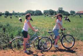
The relative
flatness of the Levels and Moors make the area ideal for outdoor
recreation. For cycling enthusiasts, there are circular routes of
between 22 and 28 miles in length and feature The Withy Way, the
Isle Valley, the Avalon Marshes and the Peat Moor Routes
For
more details, contact the Somerset Visitor Centre (01934 750833).
There are also
four circular rides around Sedgemoor and the West Country Way links
to Route 3 of the National Cycle Network.
Ramblers and
walkers can enjoy the following major routes in the Levels and Moors:
1) MacMillan Way West (www.macmillanway.org)
2) River Parrett Trail (www.riverparrett-trail.org.uk)
3) Celtic Way
|
|
| Food
& Drink |
|
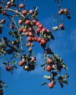
The area is well known for its prize-winning ciders, such as those from Burrow Hill Cider Farm. This is home to The Somerset Distillery and Somerset Royal Cider Brandy. Smoked salmon, trout and eel are also famous throughout the Levels and Moors. |
|
| LEVELS
& MOORS HISTORY |
|
At
the start...
After the last glaciation
10,000 years ago, the sea level rose and all of the Levels and Moors
were under water. At around, 4,500BC peat deposits began to form
in salt marsh, fen and raised bog environments and the Levels and
Moors began to emerge.
To cross these wetlands and reach the islands of rock and sand in
the valleys, prehistoric people built wooden trackways - these survive
to the present day due to waterlogging of the peat areas. The oldest
was the Sweet Track built in 3806 BC
Reconstructions
of prehistoric roundhouses and trackways can be found at the Peat
Moors Centre (01458 860697).
Iron
Age ...
The
remains of Iron Age villages have been found in the wetlands near
Meare and Glastonbury. The Meare settlements were seasonal trading
centres but the one near Glastonbury was permanently occupied, although
it could only be reached by dugout canoe.
Roman
Times ..
In
Roman times, the first sea and river defences were built and traces
of Roman fields still exist in the Axe valley. A salt-mining industry
was based around Woolavington, Burtle and Burnham. At the end of
the Roman period, the defences failed and large scale flooding took
place.
The Saxons chose the islands in the moors as locations for Monastic
centres. These included Athelney where King Alfred also built a
fort in the 9th century - this led to his successful campaign to
drive out the Danish Vikings.
Sumersaeta...
The rich summer grazing land on the Levels and Moors may have given
rise to the name 'Sumersaeta' - land of the summer people - from
where Somerset gets its name.
Middle
Ages ...
In the
Medieval period, the ecclesiastical estates of Glastonbury, Wells
and Muchelney owned large parts of the Moors which they began to
enclose and protect from flooding. This included building floodbanks,
such as Burrow Wall that now runs beside the A361 from Othery to
Burrowbridge. The courses of the rivers were also straightened for
better drainage and as sources of power for the mills.
The
wetlands remained important for wildfowling and fishing and other
products of the area were timber, peat and reeds.
Land
reclamation ...
Between
1400 and 1770, some land reclamation took place but, following the
dissolution of the monastries, most land was not church owned. There
was considerable opposition to large scale drainage work which would
result in the loss of 'commoners' rights, such as cutting peat for
fuel and grazing.
In 1685, the last battle fought on English soil occurred at Westonzoyland
where supporters of the Duke of Monmouth were defeated by King James
II's army.
From
1770 to 1840, the main period of enclosure took place, with many
rhynes or ditches cut, draining and dividing the land into rectangular
units - this led to much of the pattern of roads and farms we see
today. Tidal sluices and new or straightened river channels were
created, including King's Sedgemoor Drain and South Drain. Commoners
agreed to this reclamation in return for small plots of their own.
|
|
20th Century development...
In the 20th century the new Drainage Boards were set up and steam gave way to diesel for the pumping of water to prevent flooding. The Huntspill River (created in 1940) led to more efficient drainage, which in turn allowed for better field drainage. During the second half of the 20th century the demand for horticultural peat from the Brue Valley soared and mechanical excavation took over from hand digging. Strict controls now limit this Industry. |
| THE WILLOW INDUSTRY - Did you know....? |
|
Willow has played an important role in the Levels and Moors and
even in prehistoric societies it was used in the construction of
trackways and baskets.
Iron Age people made hut walls with them and the Romans prized willows
as highly as corn.
In the 13th century, there is Somerset's first recorded basket maker.
The Queen's Guards bearskins have a willow framework and during
the two world wars willows were woven into pigeon baskets and airborne
panniers for dropping supplies.
Somerset willows have even travelled to the Desert and Polar regions
in the form of balloon baskets.
The growing of willows still has a great role in the Levels and
Moors and traditional basketmakers make many different kinds of
baskets for general sale.
Sculptors even create garden objects and modern art out of willows
and it is used to reinforce riverbanks, thatch houses and turned
into artist's charcoal.
For
more details, visit www.celebratingsomerset.com/willow
|
| WILDLIFE |
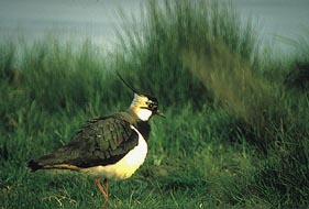
The
Levels and Moors are rich in wildlife. It is a Special Protection
Area (and Ramsar Site) which makes it internationally important
for migrating birds, such as Lapwing and for breeding waders.
All rely on the wet ground to allow them to probe for insects
and worms.
This
wetland is one of the few places in England where otters survive
and many other rarities exist, including unusual dragonflies,
damselflies, water beetles, crickets and grasshoppers.
Both
the land and water are special with 22 butterfly species depending
on the flower meadows, while the main ditches are a last link
with the country's original marshland.
|
Breeding
Birds
Migratory
birds, such as Yellow Wagtail and Sedge Warbler nest in the wetland
through the summer, as do waders like curlews. These and the less
common Redshank and Snipe all depend on wet grassland.
Herons
nest in the woodland around West Sedgemoor and are often seen feeding
on fish, eels and frogs in the ditches and rhynes.
Wintering Birds
It is vital in winter that the Levels and Moors have at least some surface splash flooding, as overwintering birds, such as Teal, Pintail and Plovers depend on these flooded areas.
Birds of prey also need the high water table. These include Merlin and Peregrine Falcons in winter and Marsh Harriers in summer.
Meadow Flowers
Many of the plants growing in the wetter, unploughed meadows - Ragged Robin, Marsh Marigold and Meadowsweet - are descendants of those marsh flowers found preserved in the peat. Far fewer are found in fertilised pastureland.
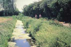
Rhynes
These ditches are man-made but have been colonised by plants that inhabited the old wetland pools - notably floating aquatics and rushes. The ditches are cleaned on a strict rotation so plant colonies are never destroyed and they have time to re-establish themselves. |
| PLACES
OF SPECIAL INTEREST |
Willows & Wetlands Visitor Centre
P.H. Coate & Son, Meare, Green Court, Stoke St Gregory, Taunton
Tel: 01823 490249 |
This
takes its name from the willows (withies), a naturally sustainable
crop grown for use in the basket-making industry. Visitors can see
the processes involved in the willow industry and purchase items. |
The
Peat Moors Centre
Shapwick Road, Westhay, near Glastonbury
Tel: 01458 860697 |
Owned
and run by Somerset Council, this visitor centre specialises in wetland
geology, history and archaeology. |
Langport & River Parrett Visitor Centre
Westover, Langport
Tel: 01458 250350 |
This
is a gateway to the South Somerset Moors one of lowland Britain's
most unchanged landscapes. |
The
Tribunal: Glastonbury Lake Village Museum
The Tribunal, 9 High Street, Glastonbury
Tel: 01458 832954 |
A
Medieval merchant's house in the town with displays from the nationally
important Iron Age site of Glastonbury Lake Village. |
| Willow
Giant |
Situated
on the M5 near Bridgwater is Serena de la Hey's mythical willow figure.
This enormous willow sculpture is one of Somerset's most striking
features. |
| TOWNS
TO VISIT |
| Langport |
Once
an important river port this town is bustling with antique shops and
craft galleries. There is the 'hanging chapel' gatehouse in the old
town wall to see and a cycle hire centre to help you explore the local
trails. |
| Muchelney |
The
town is famous for the remains of the Benedictine Abbey (English Heritage).
The thatched priest's house (National Trust) with its large Gothic
windows is worth a visit too. |
|
Somerton
|
On
the edge of the Levels and Moors, this is the former Royal Capital
of Wessex. It is known for its 17th century architecture around the
town square. |
Tourist
Information Centres
The following Tourist Information Centres will be happy to offer information,
help and advice to all visitors to Somerset. |
Sedgemoor
Services
|
01934 750833 |
| Bridgwater |
01278
427652 |
| Burnham-on-Sea |
01278
787852 |
| Cheddar |
01934
744071 |
| Glastonbury |
01458
832949 |
| Sparkford |
01935
841302 |
| Taunton |
01823
336344 |
| Wells |
01749
672552 |
|
Yeovil |
01935
471279 |
ADVERTISE on EQUINETOURISM.CO.UK - Click here
HOME
PAGE

email: [email protected]
Telephone 00 44 (0) 1984 640668
Happy Horses Ltd, Lower Sminhays Farm, Brendon Hill, Watchet, Somerset TA23
0LG
www.equinetourism.co.uk is owned by Happy Horses Ltd
Full worldwide copyright and all rights retained ©2004-2007 ongoing Happy Horses Ltd. Please read our Disclaimer
|