Sponsored
by
The Exmoor National Park Authority
|
|
Contact
details
Exmoor
National Park Authority
Exmoor House, Dulverton, TA22 9HL
Telephone 01398 323665
|
|
EXMOOR
NATIONAL PARK
|
Breathtakingly
beautiful riding
Straddling
the boundary between Devon and Somerset, Exmoor is a high plateau
taking its name from the River Exe, which rises there
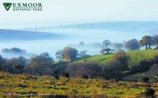
Exmoor has been described as a seemingly soft and gentle place where
the elements have combined to create a beautiful, fragile landscape.
It is for beauty, peace and being at one with nature, and for exploring
- a place with many secrets.
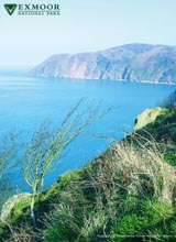
Along the coast are England's highest sea cliffs, revealing hazy views
of Welsh mountains. From the plateau run rivelets, which seem benign
but can burst into torrents, etching the landscape with steep little
combes. These separate the rounded hillsides and heath-topped ridges
and in them nestle ancient woodlands and equally ancient farmsteads.
Exmoor is an area of great variety and, despite its small size, always
has something new to offer.
Once visitors have begun to explore on foot or horse they tend to
return time and time again. |
The
Riding Playground of England
Exmoor has been described as the 'riding playground of England'. It
is superb riding country and offers every facility for the rider.
Riding stables are scattered over the whole area and most larger settlements
have their tack shop, vet and farrier.
The locals are heavily involved in equestrian culture. There is every
sort of hunting, eventing, point to points, gymkhanas and shows.
Notable are the Exmoor Spring Horse Show, Exmoor Pony Society Stallion
Parade and Golden Horseshoe Ride, all in May, the Exmoor Carriage
Driving Festival at the end of July and Brendon Pony Show in August.
Bampton Fair developed around its Exmoor pony sales. The ponies have
now gone, but the fair still flourishes. |
|
|
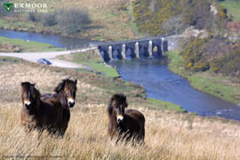
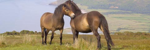
Above:
Exmoor ponies above Landacre Bridge on the River Barle |
|
History
The highest ridge culminates in the 1704ft Dunkery Beacon, a name
reflecting former times when smoke or fire were the most rapid way
of passing messages or warning of danger. The area has been settled
since the 7th Century BC and the whole landscape reflects its history.
Many place names date from Celtic times when Welsh was the local
language.
The moorland is fragmented. The motorist would be forgiven for missing
it altogether, as much was enclosed over the last two centuries
with Beech topped hedgebanks, which line wide-verged 'enclosure
roads' obsuring many fine views waiting to be discovered by the
rider.
The hedgebanks are the stitching in the patchwork of small fields
which provide pasture for sheep and beef cattle. The dried leaves
of autumn shelter the stock from winter winds and drifting snow.
With the low winter sun behind them they come alive again with russets,
ochres and gold until they are ousted by the downy olive leaflets
of spring.
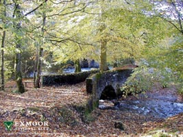
The heyday of the sheep on Exmoor was probably in medieval times,
when the woollen industry was at its height. Many of today's bridleways
developed, along with tiny stone bridges, as routes for the packhorse
carrying wool and cloth, although several have been in use since
prehistoric times. Until the 19th Century, the moorland was used
for summer grazing only and many ancient routes developed as drove
roads for seasonal movements of stock for grazing or market.
The moors and heaths offer quiet recreation and chance for solitude,
shared with the red deer, wild ponies and buzzards for which Exmoor
is famous. These are truly wild animals and not easily approached,
but more easily on horseback as the horse does not appear as a threat.
The buzzards and deer can be seen everywhere, althought the latter
are more common to the east and south of Exmoor and are seen in
the open moor at dusk and dawn.
|
|
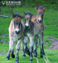
Exmoor
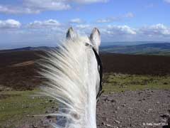
Ponies
The
ponies are confined to particular areas of moorland. Those crossed
by these routes are at Brendon Common, Winsford Hill, Warren and
Lucott Moor.
The ponies are few in number - less than 750 worldwide and only
about 200 remaining on the moor. They arrived during the Ice Age,
migrating with the seasons and the advance and retreat of the ice
sheets whilst Britain was still joined to the continent. They lived
on grasslands throughout the northern hemisphere and were amongst
the original horses to be domesticated. They were probably never
particularly numerous on Exmoor, but through the vagaries of history,
this was the only place where they survived.
|
|
|
Exmoor National Park Authority - Bridleways & Rights of Way
The National Park Authority is responsible for the upkeep of rights
of way, including bridleways. It pioneered the system of waymarking
- the use of coloured symbols to help visitors follow certain routes.
Originally, different colours were used for different routes, but
now they denote status. Small sections of these routes are permissive
- where landowners have given their consent for public use, but
where riders have no legal rights of way. In this case, consent
has been given by the Forestry Commission and National Trust, who
are major landowners on Exmoor.
There are other permissive bridleways on their properties. Often,
they are signposted and waymarked, but not always and not all of
their tracks are available to riders.
In addition, there are some parts of Exmoor where, partly through
hunting interest, it is common practice to wander freely, but local
knowledge is necessary to ride where this is acceptable and safe.
It is wise to take advice and a guide, particularly on open moorland
where boggy areas can provide difficulties for horse and rider.
It is worth noting that, even though the moorland can seem like
an open expanse, it is important to stick to the permissive routes
at all times.
|
|
EXMOOR
LEGENDS
Exmoor has a wealth of local folklore and legends and most stem from
historical facts or seasoned tales.
Stories about witches include Meldrum who supposedly lived in a cave
near Tarr Steps in the summer and then moved to The Valley of the
Rocks for the winter months.
Simonsbath is named after a Motherbrave outlaw from the days of Alfred
The Great. He secretly stole army weapons so the 'kingdom of Simonsbath'
would be left alone.
The rich travellers of the 17th century were aware of an Exmoor highwayman
called Tom Faggus (he's named in the book Lorna Doone). He was born
in North Molton and worked in a forge, before seeking more lucrative
self-employment. He was caught and hung in 1671. |
|
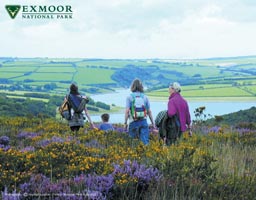
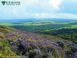
Above:
View from Winsford Hill into the Barle Valley above Tarr Steps |
THE
BEAST OF EXMOOR
In the last 30 years there have been many 'sightings' of a strange
beast prowling on Exmoor. Most tell of a large, black cat with ferocious
eyes that, when spotted, disappears into the undergrowth. It could
be a panther or puma but attempts to catch the 'beast' have failed
and some believe the rumours are false. However, sheep-killings have
occured on the moor, though no humans have ever been bothered, so
the story of the beast goes on... |
|
HOW
TO GET TO EXMOOR
Exmoor is easily accessible from most parts of the country via the
M5 (junction 24 to 27). The northern part of the moor is best accessed
from the A39 to Minehead, Lynton and Lynmouth. Distances to Minehead
Bristol - 63 miles Cardiff - 105 miles Exeter - 50 miles London
- 195 miles Plymouth - 95 miles There are two local airports at
Bristol and Exeter, all within 1 1/2 hours of Exmoor and receiving
local and international flights. Railway stations for onward access
to Exmoor are at Taunton, Tiverton Parkway, Exeter and Barnstaple.


| EXMOOR
TOWNS AND VILLAGES |
| Bossington
|
A
peaceful village well known for its charming cottages and picturesque
walk that leads to the pebbled beach. The filming of the Famous
Five by Enid Blyton took place in the vicinity. |
| Brompton
Regis
|
A
lovely parish on the southern limits of Exmoor. The surrounding
scenery is breathtaking and there is easy access to Wimbleball
Lake for water sports, camping and walking. |
| Combe
Martin |
This
has a sloping High Street along the valley to a small beach.
The unusual Pack of Cards Inn is worth visiting as it was built
to resemble a pack of playing cards. |
| Dulverton
|
A
beautiful country town beside the River Barle and popular with
anglers and walkers. There are many interesting shops, including
an antique dealer and rare book seller. It is also home to the
headquarters of the Exmoor National Park Authority. |
| Dunster
|
A
Medieval village which has changed little through the centuries
and is brimming with fascinating shops and tea rooms. It is
shadowed by the magnificent Dunster Castle which has wonderful
views of Wales and magical gardens. |
| Exford
|
A
popular and pretty village which is situated around a triangular
green and near to the river Exe. It has pubs and restaurants
and easy access to the moor for riding, hunting and walking.
It is also the main location for the Golden Horseshoe Endurance
Ride. |
| Lynmouth
and Lynton |
These
two places are linked by the cliff railway with Lynton sitting
600ft above Lynmouth. The latter is on the coast while Lynton
has stunning views of Wales and the Bristol Channel. The mysterious
Valley of the Rocks is also nearby. |
| Minehead
|
A
traditional English seaside resort with a mile-long seafront
and a curving stretch of sandy beach. It has many shops and
places to stay and is home to the Butlins resort. |
| Porlock
|
Porlock
sits in a natural bowl and is flanked on three sides by upland
Exmoor. The Lynmouth road runs through the High Street and up
the famous Porlock Hill. This has a 1 in 4 gradient and hairpin
bends - not for the faint hearted driver or speed merchant. |
| Porlock
Weir |
A
beautiful hamlet and small fishing port just to the west of
Porlock. Car parking is available for simple access to the pebbly
beach and there are a handful of lovely hotels and restaurants
to enjoy |
| Selworthy
and Holnicote Estate |
This
pretty village lies on a wooded hillside below Selworthy Beacon.
The village is owned and preserved by the National Trust and
many walks and rides can be enjoyed locally. The enormous Holnicote
Estate contains one of the largest National Nature Reserves
in England and has 6 miles of heather moorland, 5 miles of coastline
as well as numerous archaelogical sites. Point to points and
other horse meets are held on the estate throughout the year.
|
| Simonsbath
|
A
small village in a sheltered valley of the River Barle, ideal
for walking or admiring the surrounding moorland. |
| Watchet
|
Watchet
was home to an ancient port. The railway station is part of
the West Somerset Steam Railway which links Mineahead and Bishops
Lydeard, near Taunton. |
| Wheddon
Cross |
A
small village that lies a few miles from Dunkery Beacon, the
highest point on Exmoor. The valley of the snowdrops is also
nearby for walkers to enjoy in spring. |
| Wiveliscombe
|
An
old market and clothing town that is set below the beautiful
Brendon Hills. |
 |
Don't miss this!
CLICK HERE to see Exmoor-based photograher, Sally Huett's amazing Photo Album - 'Riding on Exmoor'
Sally gives us a unique glimpse of the spectacular horse riding offered within Exmoor National Park
|
|
| Our thanks to
Exmoor National Park Authority and The British Horse Society for much
of the information in this editorial section. ©Photographer Heather
Lowther and ENPA. No reproduction of any images without written approval. |
| |
ADVERTISE on EQUINETOURISM.CO.UK - Click here
HOME
PAGE

email: [email protected]
Telephone 00 44 (0)1643 862785
EQUINETOURISM.CO.UK HAS MOVED!
Happy Horses Ltd, Holt Ball, Luccombe, Minehead, Exmoor, Somerset TA24 8SZ
www.equinetourism.co.uk is owned by Happy Horses Ltd
Full worldwide copyright and all rights retained ©2004-2007 ongoing Happy Horses Ltd. Please read our Disclaimer
|